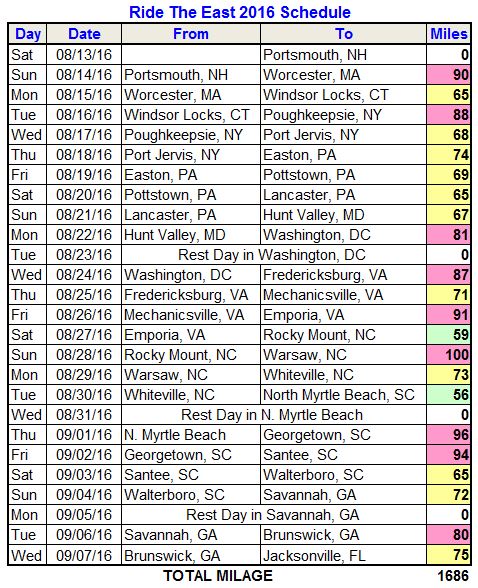
Day 31: St Joseph to Chillicothe

Today’s Highlights:
It’s hard to believe that I cycled ninety miles today, because it felt like twenty. Maybe it was the great weather, or the beautiful pastoral scenery, or the rolling hills and smooth roads. Maybe it was the previous rest day or the four weeks of conditioning, or all of the above. Most of the riders agreed that today was a great ride.

We left St. Joseph Missouri with a clear sky and a comfortable 58 degrees. A light wind from the north did not effect our predominately easterly route. The temperature slowly climbed into the eighties by afternoon, which was still quite comfortable. The terrain was very hilly again. There wasn’t a flat stretch until about mile 81 to 82. But that’s what made it so fun. I just rolled over one hill after another with relative ease. We traveled on quite country roads all day, passing farms and ranches. Occasionally, there were horses or cattle. The houses on most of these farms seem to be much more modern or updated than those I saw west of here. The farms are still huge and the houses separated by miles sometimes. A few towns we passed through had a population of only 100 to 200. Their town centers had small house and quite streets. Our first rest stop was in a slightly bigger town, Maysville. One old local gentleman came up to chat with use. He handed Gene a large stack of 4″x4″ paper as a gift, and suggested he give each rider a small hunk of it so we could take notes about our trip. He wanted us to have something to remember his town by. It was a very friendly gesture, and I will remember him. Our next stop was in Jamesport, in Amish country. I saw some people traveling by horse-drawn buggies. As I came up behind one of them, two small girls peeked out the back window. Perhaps they were curious about me and my funny bike clothes. I was surprised how easy it was to cycle passed them. Horses don’t trot very fast. There was one Amish farm with several buggies parked in front, and a young boy riding a miniature cart pulled by a pony.

Our final town was Chillicothe Missouri. It’s a large city that seems quite prosperous. The bread slicing machine was invented here, so it is known as “the home of sliced bread”. There is a large mural on a main street building commemorating this. There were several other very nice murals.

Pictures Of The Day:

[photoshelter-gallery g_id=”G0000F7f88E3ZP.0″ g_name=”Day-31″ f_show_caption=”t” f_show_slidenum=”t” img_title=”casc” pho_credit=”iptc” f_link=”t” f_send_to_friend_btn=”t” f_fullscreen=”t” f_smooth=”t” f_up=”t” f_topbar=”t” f_bbar=”t” f_htmllinks=”t” f_mtrx=”t” fsvis=”f” width=”400″ height=”300″ bgcolor=”#000000″ btype=”new” bcolor=”#CCCCCC” crop=”f” twoup=”t” trans=”xfade” tbs=”5000″ f_ap=”t” bgtrans=”f” linkdest=”c” f_constrain=”f” f_bbarbig=”” f_enable_embed_btn=”f” f_show_watermark=”f” target=”_self” wmds=”llQ6QNgpeC.p1Ucz7U.Y5fFr4tkmFePn_kAIAW5li2Dgaq70B2iTL0tyaT4RcLCaP5tbiQ–” ]

Go to full Cross Country Bike Trip Gallery

Statistics:
Zoom and pan the map to explore the route. Click the name or ‘View Detail’ to view more information at Garmin Connect.

Posted in 2013 Cross Country Bike Trip, Biking | 3 Comments

Day 30: St Joseph Missouri

Today’s Highlights:
We are on day thirty of our adventure and it is our third rest day. Tomorrow we start a string of high-mileage days. Since there is little to say about a day of chores and downtime, I have selected a set of images to highlight all the riders of this cross country challenge.

But first, we say goodbye to one of our favorite members. Dave Kokinda left for home today, as planned. He had signed up for the first three sections of the tour, and cycled across half the country with us. He is an excellent cyclist, and I was lucky to ride with him often. He is also one of the funniest guys I have ever met and everyone enjoyed his good humor everyday. We will all miss him.

Thirteen riders and four staff continue on for the entire coast to coast adventure.

Meet The Riders: (in no particular order)

Dave Kokinda from New Jersey (San Francisco to St Joseph)
 (John Aylward)

Ken Harris from Taxas (coast to coast)
 (John Aylward)

Ken Koele from South Carolina (coast to coast)
 (John Aylward)

Diego Betita (coast to coast)
 (John Aylward)

Steve Lange from Illinois (coast to coast)
 (John Aylward)

Mike Meinke from Ohio (coast to coast)
rider (John Aylward)

Bud Seabeck from Ohio (coast to coast)
rider (John Aylward)

Chris Harper from Minnesota (coast to coast)
rider (John Aylward)

Dave Marklund from Minnesota (coast to coast)
rider (John Aylward)

Emma Mason from England (coast to coast)
rider (John Aylward)

Tom and Tommy Evans from Colorado (coast to coast)
rider (John Aylward)

Mark Brandjord from Washington (coast to coast)
rider (John Aylward)

Meaghan Fondiller from New York (San Francisco to Salt Lake City)
rider (John Aylward)

Jed Beitler (San Francisco to Salt Lake City)
rider (John Aylward)

Andy Hiroshima from California (San Francisco to Salt Lake City)
rider (John Aylward)

Millard Yoder from Florida (Rocky Mt tour)
rider (John Aylward)

Andy Kaplan our mechanic
rider (John Aylward)

Gene and Jane Emborsky our support crew
 (John Aylward)

Michele Sahli our ride leader
 (John Aylward)

Posted in 2013 Cross Country Bike Trip, Biking | 3 Comments

Day 29: Topeka Kansas to St Joseph Missouri

Today’s Highlights:
We completed our traversal of Kansas today, entering Missouri in the town of Rushville. Our final fifty seven miles across Kansas were just as enjoyable as the previous days. For the first several miles we cycled through the capital of Kansas, and saw a little bit of the north end of the city. It was quite nice and very quite since it was early Sunday morning. Heading north, we quickly entered the rural hills again. Like yesterday, there were farms with crops, or with cattle or horses. Because of the hilly terrain and an increased density of trees, the vistas were less expansive.

We crossed the Missouri River on the new Amelia Earhart Memorial Bridge. As you would expect, the next forty miles into Missouri had similar landscape to its neighboring state. It was very hilly. Our elevation only varied from 750 feet to 1100 feet today, but we climbed a total of 3061 feet with all the ups and downs over the eighty seven mile ride. There was also a constant wind today that was usually against us. It was not too strong except for an occasional gust, but it did increase the work for the entire ride.

Once we entered St Joseph, Missouri, part of the route was on the SW Parkway. It was a very nice winding road through parks, making it fun, scenic and quite. I completed the ride in 7-1/2 hours today. We are lucky to be enjoying the best weather in US right now. Although we had to ride against the wind, it attributed to the mild temperature. It was a pleasant ride today.

Pictures Of The Day:

[photoshelter-gallery g_id=”G0000C5xGsbxDYlM” g_name=”Day-29″ f_show_caption=”t” f_show_slidenum=”t” img_title=”casc” pho_credit=”iptc” f_link=”t” f_send_to_friend_btn=”t” f_fullscreen=”t” f_smooth=”t” f_up=”t” f_topbar=”t” f_bbar=”t” f_htmllinks=”t” f_mtrx=”t” fsvis=”f” width=”400″ height=”300″ bgcolor=”#000000″ btype=”new” bcolor=”#CCCCCC” crop=”f” twoup=”t” trans=”xfade” tbs=”5000″ f_ap=”t” bgtrans=”f” linkdest=”c” f_constrain=”f” f_bbarbig=”” f_enable_embed_btn=”f” f_show_watermark=”f” target=”_self” wmds=”llQ6QNgpeC.p1Ucz7U.Y5fFqs.xBaYyvQirtvhNylezGDR36z0B.zz_E74HKoGn.99TEbg–” ]

Go to full Cross Country Bike Trip Gallery

Statistics:
Zoom and pan the map to explore the route. Click the name or ‘View Detail’ to view more information at Garmin Connect.

Posted in 2013 Cross Country Bike Trip, Biking | Leave a comment

Day 28: Abilene to Topeka

Today’s Highlights:
It was another delightful day for cycling. The weather was beautiful, with a clear blue sky in the morning and high puffy clouds in the afternoon. Comfortable 60-degree temps started our morning, and the heat of the 90-degree afternoon was offset by a north wind. Our 108-mile route from Abilene to Topeka took us through the Flint Hills region in eastern Kansas. I had not known about this area, and was pleasantly surprised by all the rolling hills and lush green landscape. A shallow layer of limestone made it impractical for early settlers to farm here, and as a result it has been used for cattle ranching. It is the last expanse of intact tallgrass prairie in the nation. Once, millions of bison roamed here, but unfortunately they were nearly exterminated. It was amazing to see the green prairie stretching for miles and miles, especially when we crested some of the higher hills and could see it in all directions. What a sight it must have been with its wildlife centuries ago. Today, I saw occasional herds of cattle, but none of them very large. I saw one coyote also.

In a few places, the road was cut through a hill, and a cross-section the honey-colored limestones below the topsoil was visible. I also saw a few old buildings and barns built from this stone. I am not certain, but the church in picture 6034 looks like it was built from this local stone.

Some farms with corn, wheat or other crops were seen on our ride today, but far fewer than central and western Kansas. We rode through a few very tiny towns. White City, only a few blocks long, had a brick main street and a nice town park where we had our first rest stop. Eskridge was slightly bigger, and we also enjoyed their local park for our second rest stop. The village of Dover had one cafe and not much else. Across from the cafe was a piece of yard “art” made from discarded junk, including a bicycle. In the next several miles, I saw several other yard ornaments made from discarded bicycle parts and other stuff. I had to stop for pictures just because of the bike theme.

I completed my ride in Topeka at 2:06 PM, a little under eight hours elapsed time. I had a better-than-average pace going for the first seventy five miles, but heading into a strong north wind during parts of the last twenty five miles cut my overall speed down. Still, it was a good pace for me, and a pleasant 108 miles. We ended at the northwest corner of Topeka, and will leave tomorrow heading northeast. We will not see any of this big city except the hotel we are in. That’s okay. We get to see plenty of the beautiful Kansas countryside.

Pictures Of The Day:

[photoshelter-gallery g_id=”G0000hU82XdcrMqY” g_name=”Day-28″ f_show_caption=”t” f_show_slidenum=”t” img_title=”casc” pho_credit=”iptc” f_link=”t” f_send_to_friend_btn=”t” f_fullscreen=”t” f_smooth=”t” f_up=”t” f_topbar=”t” f_bbar=”t” f_htmllinks=”t” f_mtrx=”t” fsvis=”f” width=”400″ height=”300″ bgcolor=”#000000″ btype=”new” bcolor=”#CCCCCC” crop=”f” twoup=”t” trans=”xfade” tbs=”5000″ f_ap=”t” bgtrans=”f” linkdest=”c” f_constrain=”f” f_bbarbig=”” f_enable_embed_btn=”f” f_show_watermark=”f” target=”_self” wmds=”llQ6QNgpeC.p1Ucz7U.Y5fFpAnsAB08lYU0YUKvYfifJMbb2aZV8VXKYcbERUivvHc9sTQ–” ]

Go to full Cross Country Bike Trip Gallery

Statistics:
Zoom and pan the map to explore the route. Click the name or ‘View Detail’ to view more information at Garmin Connect.

Posted in 2013 Cross Country Bike Trip, Biking | 2 Comments

Day 27: McPherson to Abilene

Today’s Highlights:
Kansas just keeps getting better on our easterly journey through it! Today’s ride was one of my favorite of the trip so far. We were back on quite, narrow country roads, surrounded by farms and pastures and fields of tall grass. There was a lot of green and lots of trees. In places, tall trees lined the road and provided shade that we have been without for many days. It reminded me of the rural roads I often ride in Pleasant Valley and Millbrook New York, and it felt like home.

We had another early start at 6:15 AM. Last night’s violent rainstorm cooled things down significantly, and the humidity also dropped a little, giving us a very pleasant morning. The roads were smooth and lightly traveled. While the route was still “flat” by most standards, there were many gentle hills that added interest to the landscape. We passed through a few little towns again today. There is something about all of them that makes you feel like they are very friendly places. Even early in the morning when the streets are quite and no people are out, there is a welcoming sense that is comforting. I saw two buffalo today, but was not able to get a good picture of them. Other than that surprise, there were only a few sightings of cows, goats and horses. The land use here is primarily for crops of wheat, corn and clover. At a couple river crossings (I think it’s the Smokey Hill River), the sky filled with swallows. They like to be near the water and take advantage of nesting under bridges. I’ve noticed this as a common occurrence since Nevada.

One highlight of the day was reaching the halfway point in our adventure. We have covered 1,948 miles so far, and have about that much more before reaching the Maine border.

I arrived in Abilene around 11:00, and since there was plenty of time left in the day, I took a side trip to the Dwight Eisenhower home and museum. It was interesting to see the small house where he and five brothers were raised, and to be reminded how some of our most important presidents came from such simple beginnings. The museum was filled with history that would have taken hours to go through, but I took a quick tour.

Pictures Of The Day:

[photoshelter-gallery g_id=”G0000jq4vfYoEuQc” g_name=”Day-27″ f_show_caption=”t” f_show_slidenum=”t” img_title=”casc” pho_credit=”iptc” f_link=”t” f_send_to_friend_btn=”t” f_fullscreen=”t” f_smooth=”t” f_up=”t” f_topbar=”t” f_bbar=”t” f_htmllinks=”t” f_mtrx=”t” fsvis=”f” width=”400″ height=”300″ bgcolor=”#000000″ btype=”new” bcolor=”#CCCCCC” crop=”f” twoup=”t” trans=”xfade” tbs=”5000″ f_ap=”t” bgtrans=”f” linkdest=”c” f_constrain=”f” f_bbarbig=”” f_enable_embed_btn=”f” f_show_watermark=”f” target=”_self” wmds=”llQ6QNgpeC.p1Ucz7U.Y5fFoX5AbILQwob.dcdRDECcuxOlFUo2IyaRED67vvKUzAi1zFA–” ]

Go to full Cross Country Bike Trip Gallery

Statistics:
Zoom and pan the map to explore the route. Click the name or ‘View Detail’ to view more information at Garmin Connect.

Posted in 2013 Cross Country Bike Trip, Biking | Leave a comment

Day 26: Great Bend to McPherson

Today’s Highlights:
It was another fantastic day of cycling. The morning ride was very peaceful. We left the hotel at 6:15 just as the sun was rising. The short ride through the city of Great Bend was quite, and the next couple hours out in the country continued that way, with very little traffic. The songs of birds and crickets replaced the noise of cars and truck passing quickly by us. We had made the early start to avoid riding in the late afternoon heat, and the additional bonus was beating the traffic.

Today’s directions were simple – leave the hotel, ride 64 miles, turn left into another hotel. Not only that, the road was simply flat and straight with hardly a bend in it. It was restful on the mind to just cycle along and enjoy the view and the sounds of nature. Like yesterday, we passed one great farm after another, and this morning I saw several combine harvesters working the fields. Where we crossed the Little Arkansas River around mile forty, there were gently rolling hills to add some visual interest. They were insignificant to cycle up,and everyone seemed to make good time today.

I stopped to talk to another cyclist who was going in the opposite direction. She was pulling a huge load behind her mountain bike. She too was going coast to coast, but alone. She started from Maryland last year, took the winter off in Kansas City, and is pressing ahead now to California. Check out the picture of her rig.

We passed through a quaint little town called Ellinwood, and later the nice town of Lyons. We ended in the town of McPherson, which is much larger and also looks like a very pleasant place. I ended my ride before 11:00 AM today, when the temperature was still below 100. It is supposed to reach 106 later today. We have a little extra time to recover or explore this afternoon.

Pictures Of The Day:

[photoshelter-gallery g_id=”G0000xCghlzMlC1k” g_name=”Day-26″ f_show_caption=”t” f_show_slidenum=”t” img_title=”casc” pho_credit=”iptc” f_link=”t” f_send_to_friend_btn=”t” f_fullscreen=”t” f_smooth=”t” f_up=”t” f_topbar=”t” f_bbar=”t” f_htmllinks=”t” f_mtrx=”t” fsvis=”f” width=”400″ height=”300″ bgcolor=”#000000″ btype=”new” bcolor=”#CCCCCC” crop=”f” twoup=”t” trans=”xfade” tbs=”5000″ f_ap=”t” bgtrans=”f” linkdest=”c” f_constrain=”f” f_bbarbig=”” f_enable_embed_btn=”f” f_show_watermark=”f” target=”_self” wmds=”llQ6QNgpeC.p1Ucz7U.Y5fFv35bV7c_dUrSctbNpVEL3LSBSF00jBHV0G3KO7MjpvCmltw–” ]

Go to full Cross Country Bike Trip Gallery

Statistics:
Zoom and pan the map to explore the route. Click the name or ‘View Detail’ to view more information at Garmin Connect.

Posted in 2013 Cross Country Bike Trip, Biking | 5 Comments

Day 25: Dodge City to Great Bend

Today’s Highlights:
Today we cycled from Dodge City Kansas to Great Bend, the city named for the bend in the Arkansas River as it turns from a northeast flow to the southeast. We have followed the Arkansas since Salida Colorado, and our route will leave its path now. Our ride continued along US 50 for the first thirty six miles, then onto US 56 for the next fifty. The latter is more rural and pleasant, although it also has significant truck traffic. Other than a few small towns we passed through, the landscape consisted of farms stretching to the horizon. And in these flat plains of Kansas, the horizon is a long way off in every direction. There were places where the scent of wheat filled the air, and one stretch where I enjoyed the smell of fresh cut grass – something not experienced in the desert climate we were in for nearly three weeks. We are seeing more trees too, including large oaks, and it’s nice to see so much green. No trees line the roadway yet to provide any shade.

For many miles, maybe twenty, there were windmills on both sides of US 50. Like the wheat and corn, they stretched far to the horizon. I was surprised at the immensity of the power project.

We had our first rest stop in Kinsley where there was a museum of local artifacts and a sod house like those built and occupied by the early settlers. One could have spent a couple hours there, but we took a quick look and then got back to our cycling. It was only 9:30 AM and the temperature was already in the nineties, and we wanted to keep moving to reduce our time out in the heat. With fifty miles left to go, we still had several hours left.

We passed through the town of Garfield, which was named in honor of the 20th president of the USA. If you blink driving through Garfield, you will miss it. The town of Larned was larger and had a nicely restored railroad station. Pawnee Rock was another tiny town with a main street that was still a dirt road with a few buildings that looked like they hadn’t changed in one hundred years.

For the last two hours of my ride, the temperature was over 100 according to my bike computer. I was less aware of the landscape, although it doesn’t change much anyway, and more focused on drinking and keeping my pace up to finish as quickly as possible. It was an exhausting finish, but another accomplished challenge.

This evening, after dinner, we celebrated Tom Evan’s birthday with cake.

Pictures Of The Day:

[photoshelter-gallery g_id=”G0000V58XQz7WTnk” g_name=”Day-25″ f_show_caption=”t” f_show_slidenum=”t” img_title=”casc” pho_credit=”iptc” f_link=”t” f_send_to_friend_btn=”t” f_fullscreen=”t” f_smooth=”t” f_up=”t” f_topbar=”t” f_bbar=”t” f_htmllinks=”t” f_mtrx=”t” fsvis=”f” width=”400″ height=”300″ bgcolor=”#000000″ btype=”new” bcolor=”#CCCCCC” crop=”f” twoup=”t” trans=”xfade” tbs=”5000″ f_ap=”t” bgtrans=”f” linkdest=”c” f_constrain=”f” f_bbarbig=”” f_enable_embed_btn=”f” f_show_watermark=”f” target=”_self” wmds=”llQ6QNgpeC.p1Ucz7U.Y5fFucmU8XIF0IaSFtIoScgNL9mCAp9gk2940e7futBoIb3aOIA–” ]

Go to full Cross Country Bike Trip Gallery

Statistics:
Zoom and pan the map to explore the route. Click the name or ‘View Detail’ to view more information at Garmin Connect.

Posted in 2013 Cross Country Bike Trip, Biking | 1 Comment

Day 24: Garden City to Dodge City

Today’s Highlights:
Outside the hotel this morning, it was a comfortable 70 degrees, the higher humidity felt nice after being in the desert climate for days, and the sweet aroma of cow manure hung thick in the air. Ahhh, Kansas. Our ride was a short fifty miles today, so we started one hour after sunrise. After riding a few miles through the business district on US 50, we were surrounded by farmland all the way to Dodge City. There were a lot more large fields of green or gold, more farm houses, more livestock, more activity, etc. Simply, there was a lot more life than we had seen in the previous two hundred miles. That was refreshing.

The terrain is still very flat, but with occasional rolling hills to break it up. We had an easy ride today with the wind in our favor for most of it. Thin clouds early in the morning shielded us from the sun and created a colorful sky even ninety minutes after sunrise. The road was in good condition, but I am looking forward to getting off the highways and onto country roads a few days from now.

The highlight of the day came halfway through our ride when we stopped in the town of Cimarron for a special treat at the Clark Drug Ice Creme Parlor. It is a charming old pharmacy where you can sit on stools at the counter and have an ice creme soda or other treats. Every rider stopped there. The ice cream was awesome, and the people serving us were very gracious and interested in our adventure.

I crossed into Dodge City at 11:00 am, and arrive at the hotel about fifteen minutes later. The Dodge House Hotel is decorated with western memorabilia, some nice, some corny. It’s fun to have a change from the chain hotels once in a while. It is supposed to reach 104 degrees today, so it was nice to end early. We will deal with the heat on tomorrow’s longer ride.

Pictures Of The Day:

[photoshelter-gallery g_id=”G0000_WQeVvJ8K2g” g_name=”Day-24″ f_show_caption=”t” f_show_slidenum=”t” img_title=”casc” pho_credit=”iptc” f_link=”t” f_send_to_friend_btn=”t” f_fullscreen=”t” f_smooth=”t” f_up=”t” f_topbar=”t” f_bbar=”t” f_htmllinks=”t” f_mtrx=”t” fsvis=”f” width=”400″ height=”300″ bgcolor=”#000000″ btype=”new” bcolor=”#CCCCCC” crop=”f” twoup=”t” trans=”xfade” tbs=”5000″ f_ap=”t” bgtrans=”f” linkdest=”c” f_constrain=”f” f_bbarbig=”” f_enable_embed_btn=”f” f_show_watermark=”f” target=”_self” wmds=”llQ6QNgpeC.p1Ucz7U.Y5fFtdH22ZrX2dF8yzJMlq6zm7lTBuRw5e5eQ53_NXsJzsOqrww–” ]

Go to full Cross Country Bike Trip Gallery

Statistics:
Zoom and pan the map to explore the route. Click the name or ‘View Detail’ to view more information at Garmin Connect.

Posted in 2013 Cross Country Bike Trip, Biking | Leave a comment

Day 23: Lamar Colorado to Garden City Kansas

Today’s Highlights:
We completed our second back-to-back century of our cross-country tour today. The first one was back in Utah entering Salt Lake City. After yesterday’s 120 miles, we cycled 103 today. We also left the great state of Colorado and entered Kansas. And, we are now on Central Standard Time.

The morning started with a big challenge. We had a strong headwind, and the stretch of US 50 that we were on had very rough pavement. Cycling against a headwind requires constant pressure on the pedals and usually a stronger grip on the bars. The rough pavement sends a lot of vibration to your feet and hands and seat! That was the situation for over thirty miles and almost three hours. It was quite tiring and a bit painful on some body parts.

We had our first rest stop at mile 32. A half mile later, we reached the Kansas border and Central time zone. At that point our luck changed. As if we were being welcomed to Kansas with a gift, the wind shifted just enough to tap us on the back of our right shoulder (from the SW as we traveled east). Dave and I cruised for fifteen miles into Syracuse KS at 20 mph, up from our 13 mph average during the first third of the ride. And, the road surface was also smoother. What a relief! The wind continued in our favor until we turned south one mile before the hotel.

The final phase of our eastern Colorado route was sightly prettier than yesterday, but still somewhat desolate. We are still following the Arkansas River, and some farms near its banks looked productive. Most, however, seemed barren or abandoned. In Kansas, the land looks more productive and there are many more active farms per mile than there were from Pueblo to the state border. We crossed the Arkansas River a few times today, and it is surprising how little water flows in it. It should be getting bigger as it approaches the Mississippi, but apparently irrigation efforts use up most of the water along the way. The terrain has been extremely flat since Pueblo. About sixty miles into our ride today (30 miles into Kansas), we hit some nice rolling hills. With the tailwind, they were nice to cycle on, but most of all it was pleasing to see some variation in the landscape.

Another bit of luck we had today was an overcast sky. Although that made landscape photography less appealing, it gave us some welcome relief from the sun and heat. Our route has not had shade since we left the canyons about 250 miles ago. Still, it reached the mid-nineties by the end of our ride, and my bike computer again registered over 100 on the road. It was very hot for the last several hours of the ride.

When we reached the Comfort Inn in Garden City, the staff was especially friendly and accommodating. They had for us bottles of water on ice, fresh oranges cut up, cold wet face clothes, and fresh made popcorn. All were greatly appreciated.

My total elapsed time for the 103 miles today was only seven hours, and in that time I only had 45 minutes off the bike. Most of that stationary time was spent at the two rest stops. I made very few stops to take pictures today. Seven hours is not bad for a century. However, it felt much longer than that to me. Perhaps that was because of the lack a variation in the scenery and being more focused on the road ahead rather than the world around me. Hopefully, that will improve as we continue through the Midwest.

Pictures Of The Day:

[photoshelter-gallery g_id=”G00003UpUs0qak_M” g_name=”Day-23″ f_show_caption=”t” f_show_slidenum=”t” img_title=”casc” pho_credit=”iptc” f_link=”t” f_send_to_friend_btn=”t” f_fullscreen=”t” f_smooth=”t” f_up=”t” f_topbar=”t” f_bbar=”t” f_htmllinks=”t” f_mtrx=”t” fsvis=”f” width=”400″ height=”300″ bgcolor=”#000000″ btype=”new” bcolor=”#CCCCCC” crop=”f” twoup=”t” trans=”xfade” tbs=”5000″ f_ap=”t” bgtrans=”f” linkdest=”c” f_constrain=”f” f_bbarbig=”” f_enable_embed_btn=”f” f_show_watermark=”f” target=”_self” wmds=”llQ6QNgpeC.p1Ucz7U.Y5fFsKC8g0qOpOHJH_B3NSFIycTLGxiUBN4m4PQkLQg.ZqKC42A–” ]

Go to full Cross Country Bike Trip Gallery

Statistics:
Zoom and pan the map to explore the route. Click the name or ‘View Detail’ to view more information at Garmin Connect.

Posted in 2013 Cross Country Bike Trip, Biking | Leave a comment

Day 22: Pueblo to Lamar

Today’s Highlights:
I woke up this morning feeling very tired and a little ill. I guess that’s what a rest day can do to you. My enthusiasm to start today’s 120-mile ride (our longest of the tour) was not as high as most mornings. I had a light breakfast, then hopped on my bike at 6:00 am. After a few pedal strokes, I adjusted into my normal state again. Everything felt good. Life was good. I started the ride with Ken, our fastest rider. I wasn’t expecting to be with him long, because I usually stop for a picture and loose him, or my legs just don’t keep up with his. However, today was different and I stuck to his wheel for nineteen miles. Photo opportunities were rare, and I only shot a few from the bike while cruising along. We made good time on the flat roads with a very slight tailwind, averaging about 19 mph for the first hour. The winds were forecast to swing around into our faces later in the day, so we were very happy to be covering the miles quickly before that happened.

Today’s journey was much more about the ride than the scenery, for me. Covering 120 miles in a reasonable time requires careful pacing, constant hydration, and consuming enough calories along the way. There were three SAG stops to provide us with the water and food. There were also several small towns along the way, although very little else in between. This is farming country, or at least it used to be. Most of the land that I saw could barely sustain grass or weeds. Even the yucca plants were withering. Irrigation was sparse. Many old farm houses were abandon and in disrepair. It must be quite a struggle to have a successful farm here. The Arkansas River was still close to our route, and we sometimes saw a ribbon of green (mostly Cottonwood trees) indicating where the river was. Trees were rare elsewhere.

Cycling alone after the first nineteen mile, I continued to made good time. Surprisingly, I was averaging 20 mph at the 50-mile mark. I think that’s the fastest average I ever had for that distance. It was 9:00 and the wind was still mostly in my favor, but starting to change to a cross wind. It wasn’t until about 9:30 when the cross wind started to slow my pace a little. By the time I reach the 100 mile mark, my average had dropped to 17.8, but it was still my fastest century that I can remember with only 6-1/2 hours elapsed time (about two hours faster than my normal century time at home).

I finished the 120 miles at 2:30 pm, very happy with my ride and still feeling able to do more. I guess the rest day in Pueblo really did help.

Today’s accomplishment also got me 120 miles closer to home. That feels really good too.

Pictures Of The Day:

[photoshelter-gallery g_id=”G0000WfD5GesNNDU” g_name=”Day-22″ f_show_caption=”t” f_show_slidenum=”t” img_title=”casc” pho_credit=”iptc” f_link=”t” f_send_to_friend_btn=”t” f_fullscreen=”t” f_smooth=”t” f_up=”t” f_topbar=”t” f_bbar=”t” f_htmllinks=”t” f_mtrx=”t” fsvis=”f” width=”400″ height=”300″ bgcolor=”#000000″ btype=”new” bcolor=”#CCCCCC” crop=”f” twoup=”t” trans=”xfade” tbs=”5000″ f_ap=”t” bgtrans=”f” linkdest=”c” f_constrain=”f” f_bbarbig=”” f_enable_embed_btn=”f” f_show_watermark=”f” target=”_self” wmds=”llQ6QNgpeC.p1Ucz7U.Y5fFsKC8g0qOpOHJH_B2pd3j.0KBbnsut4cgRtPiR62_mHkiCEA–” ]

Go to full Cross Country Bike Trip Gallery

Statistics:
Zoom and pan the map to explore the route. Click the name or ‘View Detail’ to view more information at Garmin Connect.

Posted in 2013 Cross Country Bike Trip, Biking | 3 Comments